Archive for the ‘Big Island’ Category

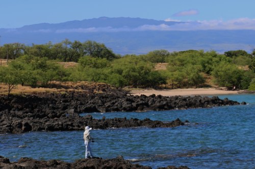
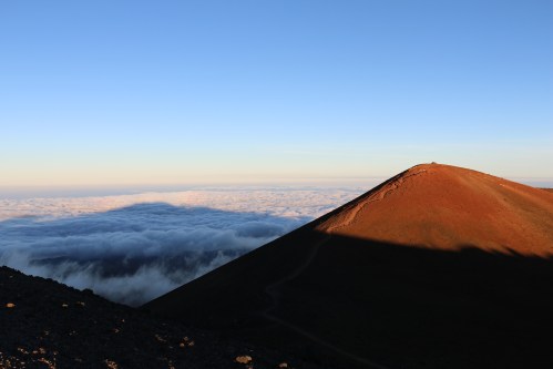
A Big Island adventure not to be missed is going to the 13,796 foot Mauna Kea Summit which at night offers the clearest and most awe-inspiring views of the night skies to rival any on Earth. I spent a lot of my time at the summit looking around and thinking “what a fantastic world we live in and I wish everyone could participate in this experience.”

Mauna Kea Summit View from the top of the summit

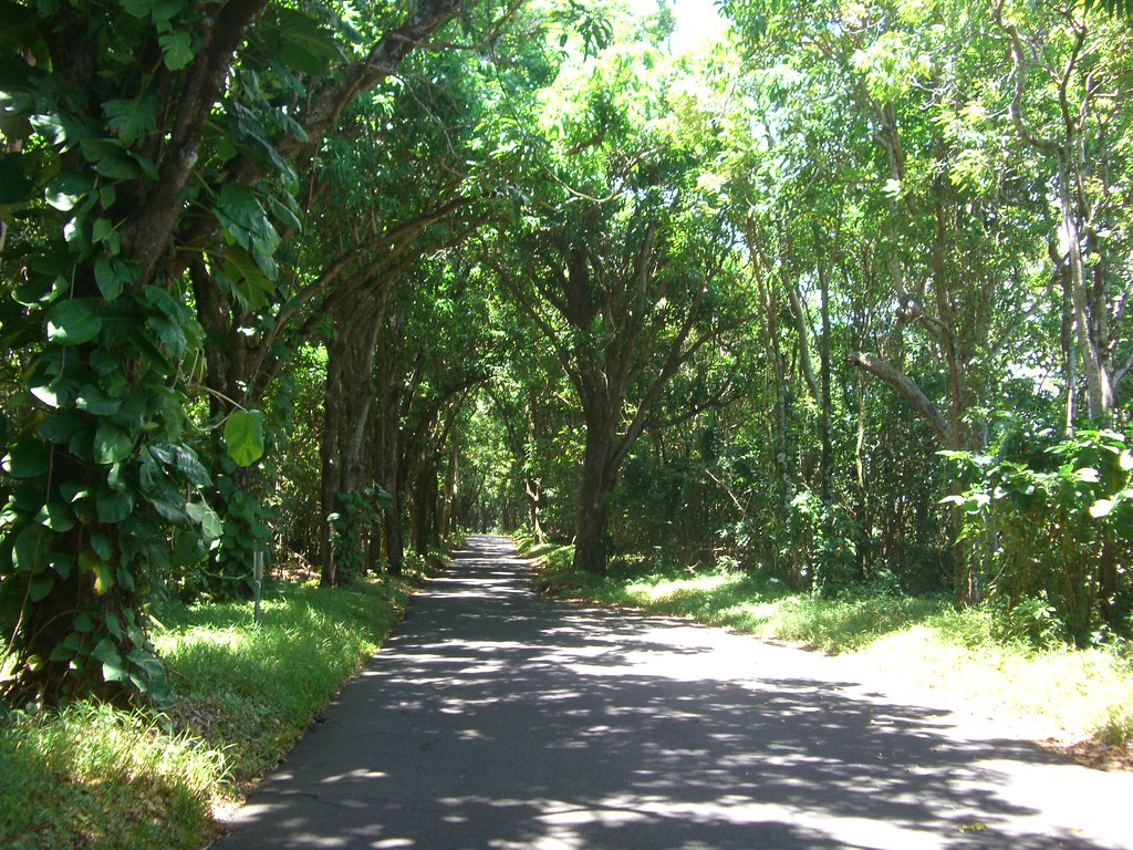
It’s not required to go with a tour group to the summit but because we didn’t rent a 4-wheel drive (required for the top part of the mountain), we decided to join a tour. We were very pleased with the knowledge and friendliness of our tour guide/driver from Hawaii Forest and Trail . The trip lasts anywhere from 7-8 hours ~ depending on weather conditions and travel time. Our trip was right around 7 hours.

Mauna Kea Sheep Station Logan III

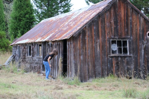
Abandoned Humuula Sheep Station

A picnic dinner is served at the historic (abandoned) Humuula sheep station located at 7,000 feet (half way up the mountain) and allows people to acclimate to the higher elevation. Some people were affected and others not at all. Thankfully, we were in the not at all category.

Throughout the tour, our guide provided a lot of historic and cultural information. Because the temperatures and winds make it downright winter-like at the top, the tour company provides winter jackets.

Mauna Kea John Patti and Logan III

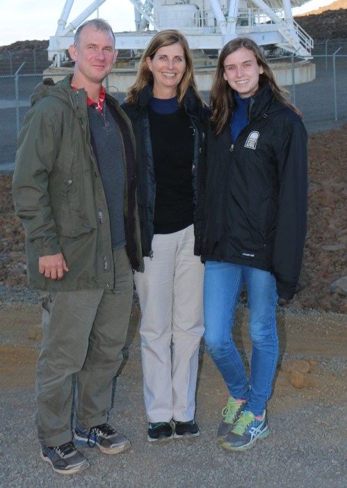
Thank goodness for the jackets provided by the tour company ~ definitely needed.

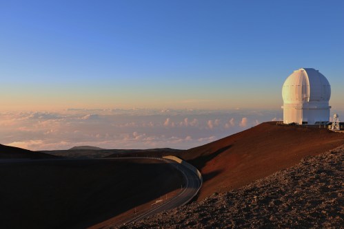
It was very interesting to be standing amongst the world’s largest collection of research telescopes.

The large dish-shaped structure is one of 10 very long Baseline Array radio telescopes that are spread out across the United States and used simultaneously. Astronomers use the telescope to make detailed studies of space objects. Each antenna is controlled remotely by the Array Operations Center in Socorro, New Mexico, but there are local site technicians at the Mauna Kea summit.

Mauna Kea Summit Sacred Hawaiian site at the top of Mauna Kea

Most sacred part of Mauna Kea and off limits to visitors

The Hawaiians consider the mountain to be one the most sacred places in the islands and it is not without controversy that it is used commercially. There is an area of the mountain which is off-limits and I’m glad most people respect it.

Mauna Kea Sun Setting

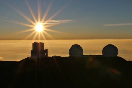
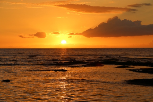
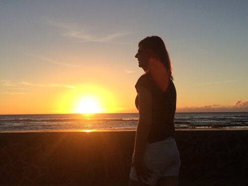
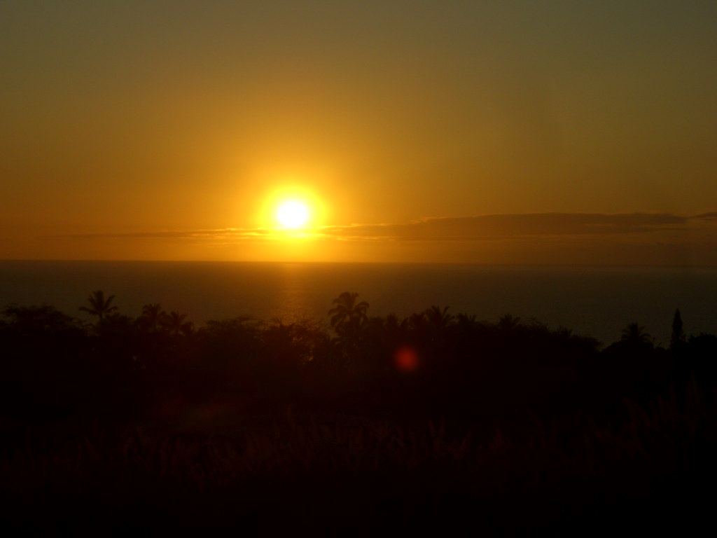
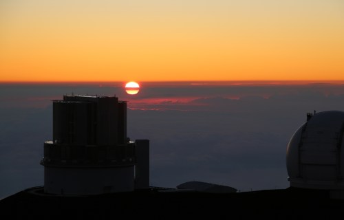
A highlight was the spectacular sunset which looked like other-wordly to me especially when the sun was low and in the clouds far below us.

Mauna Kea Summit sunset 25

On the way down the mountain, we stopped at 9,000 feet for delicious hot chocolate and star-gazing and then we stopped at the visitor’s center for a bathroom break and a little shopping in the gift shop. Photos of stargazing will follow in a future post.

Before you attempt traveling to the summit, here are a few precautions: guests should be able to hike on uneven, rocky, wet, and sometimes muddy terrain. Because of high altitude, I would caution anyone who has respiratory, circulatory and /or heart conditions, pregnancy or generally in poor health. Scuba divers shouldn’t make the ascent within 48 hours of diving. Children under 16 are not allowed on the tour. Be sure to wear closed-toe shoes, long pants and a sweatshirt/sweater. Dressing in layers is best.

Interesting Facts  about Mauna Kea:

  • It is estimated to be approximately one million years old
  • Last eruption was about 4,000 years ago
  • It is a dormant volcano but could still erupt
  • The area of Mauna Kea takes up about 28.8% of the island
  • Mauna Kea means White Mountain
  • Snow falls on both Mauna Kea and Mauna Loa

Read Full Post »

Mau’umae Beach is my favorite on the Big Island (Hawaii). It’s secluded, sandy, and I can usually have it all to myself on a weekday if I get there early enough. The water is almost always calm so it’s a great place to snorkel. If you happen to be there during the winter months, keep a lookout for whales or dolphins just offshore.

Getting to Mau’umae Beach requires a short hike from Spencer Park or you can drive from the Mauna Kea Beach Hotel. If you’re coming from Mauna Kea Beach Hotel, you will need to get an access pass from the guard shack and they only give out 10 passes per day so go early. Once you have your pass, follow the road for approximately 300 yards and take the second right turn. Continue across two small wooden bridges until you arrive at the unpaved parking area above the beach. The trail down to Mau’umae Beach is marked by a sign.

From Spencer Park, park at the far left side of the parking lot and take the coastal path for about a quarter mile. Fishing is popular along the hike and the views of Mauna Loa are spectacular!

Mau'umae Beach hike ~ Ala Kahakai Trail Fisherman and mauna loa

Along the trail to Mau’umae Beach, woman fishing and Mauna Loa in the background.

If you’re on the Big Island, I highly recommend you visit this small, secluded and beautiful beach.

Read Full Post »

Puako Rental House welcome sign

When I was younger, there was no question that I would stay with family and friends when ever I went back to the Big Island (Hawaii) for a visit. But with a family of my own now, and my desire for more privacy, I usually book several different places to stay. The island is big enough to warrant moving locations to be closer to either the volcano or the beaches.

Puako sunset favorite sunset

Sunset view from 118 Puako Beach


On our July visit, I booked an AirBnB vacation home for the first time. I’m thrilled to say the seven night stay at a two-bedroom, two bath beach house in Puako was a big success with everyone.

Puako John and Logan waiting on sunset

Waiting on Sunset in the Puako Beach House Yard

The location couldn’t have been better for us. We could see the ocean from the living room, patio and master bedroom. I love waking up to the sound of the waves crashing on shore. We were able to go to several beaches in close proximity to the rental home.

Puako biking holding hands 10

Bikes come with the Beach House rental

Upon arrival to the island, my brother loaded me up with all kinds of local foods for us to feast on while we stayed at the house. He thought of everything ~ fruits, main meals, coffee, desserts, vegetables, chips, etc. Yum! 118 Puako House came fully stocked with essentials so be sure to check in and then do your grocery shopping.

Puako House Bird

A Daily Visitor to the Beach House

Birds aren’t the only visitors to the beach house. Keep an eye out for unwelcome critters especially the dreaded centipede. They are red and nasty looking. Always check your shoes before you put them on and check your bed too. Anywhere they may hide ~ don’t come away with a painful bite.

Patti at sunset puako

If you book a home in Puako, be sure to rent one on the oceanside. The ocean breeze makes it much more comfortable during warmer days.


Read Full Post »

As a family, we’ve hiked in locations around the world and have been lucky enough to hike in Germany, Slovenia, Guam, Hawaii, Virginia, and many more. But I wasn’t surprised when my daughter deemed the Kīlauea Iki Trail on the Big Island as her all-time favorite hike. It’s a fascinating place located within the Volcanoes National Park on the Big Island of Hawaii. Kilauea remains an active volcano to this day.

fb-hawaii-kilauea-iki-trail-volcanos-national-park-sign
At the Kīlauea Iki sign, you can go in either direction but I would advise taking the trail to the right and hike counter-clockwise which will lead you through a rain forest, the 1959 lava lake, steam vents, cinder cones, and large fissures in the lava. Keep an eye out for the native nēnē (Hawaiian Goose) ~ we saw two but they were too fast to get a photo. The nēnē are the sixth most endangered waterfowl species in the world.

hawaii-kilauea-iki-trail-volcanos-national-park-bench-and-trail

hawaii-kilauea-iki-trail-volcanos-national-park-trail-v
The rainforest section of the trail is well-worn but be careful with the rocks and occasional exposed roots. We started early in the morning and didn’t see anyone else until we got to the lava lake.

hawaii-kilauea-iki-trail-volcanos-national-park-logan-on-phone-with-new-suitemates
On hikes, my daughter only uses her phone to take photos but while we were on the trail, her college released the dorm assignments and she was excited to learn where she would be living for a year. Unfortunately, it wasn’t the dorm she preferred and it was the only sad part of the hike. But, fast-forward six months later, and she’s thrilled with her suitemates and her dorm.

hawaii-kilauea-iki-trail-volcanos-national-park-logan-smelling-a-flower

hawaii-kilauea-iki-trail-volcanos-national-park-japanese-thimbleweed-ii

hawaii-kilauea-iki-trail-volcanos-national-park-ohelo-berries
The ‘Ōhelo berries are a favorite treat for the nēnē and can be found throughout the trail. It is a hardy plant that even grows on the lava. The plant is a relative to the blueberries and the berry can range in color from dark red to pale yellow.

hawaii-kilauea-iki-trail-volcanos-national-park-looking-onto-the-lava-field-trail
The amazing view from the rainforest.

hawaii-kilauea-iki-trail-volcanos-national-park-runner-along-the-trail
It was a little surreal to see a runner come through as we walked along the deserted and isolated lava crater but he obviously runs this trail frequently.

hawaii-kilauea-iki-trail-volcanos-national-park-marker-12
Be sure to follow the Ahu (stacked rocks) to find your way through to the other side of the trail. Please don’t disturb them!

hawaii-kilauea-iki-trail-volcanos-national-park-logan-and-patti-breaktime

If you go, here are a few words of advice:

  • The trail is moderate to challenging. It’s steep and rocky. The descent/ascent is 400 feet (122m).
  • It’s a 4-mile (6.4km) loop. It took us approximately 2.5 hours and we stopped for a snack.
  • The trail head is 2 miles (3.2km) from the Visitor’s Center.
  • Once you’re at the Kīlauea Iki parking lot (off of Crater Rim Drive), you may go either way from the trailhead. We preferred to go right which took us through the rainforest first then down to the crater floor.
  • Be sure to bring water, food, hat, sunscreen, camera and rain gear. Be prepared for all types of weather conditions: hot, dry, wet, windy (!). Please remember to “leave only footprints” and bring all your trash and items back out of the area.

hawaii-kilauea-iki-trail-volcanos-national-park-john-and-logan-resting-along-the-trail


Read Full Post »

Having grown up in Hawaii, I’m used to the occasional earthquake, big surf, an active volcano and unpredictable weather. And then there’s the ever-present threat of a tsunami. While having dinner with my brother this past week, he recounted his story of surviving a 7.7 earthquake, landslide and the largest locally generated tsunami to hit the Big Island in the 20th century.

In 1975, over Thanksgiving weekend, my older brother and cousins decided to go camping in Halapē which sits at the base of the 1,000 foot cliffs of Puu Kapukapu. There were eight hikers in his party ~ most between the ages 19 to 25 and one brought his dad with him. They also had four horses. This is his account as he told us the other night over dinner:

On Friday, 28 November 1975, they hiked in the early afternoon to fish and pick ‘opihi. Once the fish/’opihi were on ice, they had a campfire dinner. He was still awake when the first earthquake hit in the early morning of 29 November. Actually, it was a foreshock measuring 5.2. The second earthquake, measuring 7.7, is the one that rocked the entire area. It bounced the rock he was sitting on so that it moved in a circle. He tried to hang on but after a few seconds he found himself on the ground.

His group, along with the Boy Scout troop also camping in the area, ran for the trail that would lead to higher ground but there was a horrendous noise coming from the mountainside which they knew was a landslide  ~ the large falling rocks impeded their ascent. They turned around to avoid being hit by the boulders, but someone screamed they saw the ocean rising. There was no time to do anything else, the wave smashed into the cove and swept him away. He was tumbled under the waves until his need to breathe began urgent; he was certain he would die. His thought was “I now know what it’s like to drown.” He swam as hard as he could to get to the surface and, miraculously, made it to the top long enough to take a big gulp of breath before the second, and much larger, wave slammed into him. He was tousled towards the rock and hung onto a big boulder. His ability to hang on to the boulder is what saved him.

Unbelievably, only two of thirty-two campers perished in the tidal wave. The US Geological Survey estimated the second wave was 14 meters high (just shy of 46 feet). This tsunami was caused by the largest locally generated earthquake (part of Kilauea Volcano) ever recorded in Hawaii history and because the epicenter was only 19 miles from my brother’s location, the waves hit within a matter of minutes. Many of the surviving campers were hospitalized for broken bones, concussions, etc. My brother walked away with one or two scratches. He has one heck of a guardian angel watching out for him. It gives me the chills just thinking about it.

tsunami evacuation zone sign

We are currently staying at a beach house right on the water and we see the tsunami signs all along the road. On Friday night (9 July 2016), the tsunami sirens, located directly across the street, jolted us out of bed. We were especially alert due to the story of the 1975 tsunami we had just heard. I’m proud to say the only thing I grabbed was my purse ~ thinking that I needed my license to drive. We headed for higher ground while listening to the radio for further instructions. Turns out it was a system malfunction but I’m not sorry we evacuated ~ better safe than under water.

There’s a scene in the movie Leap Year where the lead male character asks “if your apartment was on fire and you had sixty seconds, what would you grab?” ~ I’m happy to know the only thing that mattered to me was my husband and daughter.

If you’re ever at the beach in Hawaii and there’s an earthquake, don’t hesitate ~ head for the high ground!!

Photos of the aftermath (courtesy of the Pacific Tsunami Museum):

Hawaii Beach after 1975 Tsunami


Read Full Post »

A bit of Hawaiian history: In January 1778, Captain Cook made his first visit to the Hawaiian Islands while commanding the HMS Resolution and Discovery. He and his crew are considered the first Europeans to visit the Hawaiian Islands. Cook named the island chain “the Sandwich islands” after a patron named John Montague, the Earl of Sandwich.

Originally, the crew was welcomed by the Hawaiians who were fascinated by the large ships and the use of iron. While Cook re-provisioned his ships by trading metal, some of the sailors traded iron nails for sex. The ships made a brief stop on the island of Ni’ihau then headed north to look for the western end of the Northwest passage.

A year later in January 1779, the crew returned to the islands and docked in Kealakekua Bay. The Hawaiians were celebrating the fertility god, Lono and thought the English were visiting gods. Unfortunately, the crew spent the next month exploiting the Hawaiians. During that month, a crewman died which enlightened the Hawaiians as to the crew’s mortality and the realization that they were not gods. The Hawaiians were undoubtedly thrilled and only too happy to wave goodbye to the HMS Resolution and Discovery as they sailed out of the bay on February 4, 1779.

But wait…rough seas damaged the foremast of the Resolution and, after only a week, Cook was forced to return to Kealakekua Bay. As the ships sailed back into Ka’awaloa Cove, the Hawaiians greeted them by hurling rocks and stealing a small cutter vessel from the Discovery. Captain Cook attempted to negotiate with King Kalaniopuu but it all went sideways when a lesser Hawaiian chief was shot to death. Angry Hawaiians overwhelmed the 10-man shore party and Cook plus four sailors were killed. Before the two ships sailed back to England, the sailors retaliated by killing about thirty Hawaiians.

Kealakekua Bay Captain Cook Memorial II

27-foot obelisk monument to Captain Cook was erected in 1874. The land under the monument was deeded to the UK in 1877. It’s considered as sovereign non-embassy land owned by the British Embassy in Washington DC and maintained by the British Consul–General in California.

Despite the unfortunate events in Hawaii, Captain Cook is regarded as one of the greatest explorer, navigator and mapmaker of all time. He mapped more of the earth than any other explorer. I try to imagine what it must have been like to travel as far and as wide as he did and in such arduous conditions. I complain about my 10-hour flight to Hawaii. Yet, he sailed for years on his ship.

Many people chose to kayak to Ka’awaloa Bay or take an organized boat tour there but we preferred to hike the Ka’awaloa trail. It’s a steep trek but worth it when you get to the bay and jump in the refreshing waters for a swim and a snorkel.

The trailhead is located off of Hwy 11. Turn toward to seaward side onto Napo’opo’o Road and drive to the third telephone pole which is where the trail begins. There’s limited parking and no shade so go early in the morning.

The signs at the start of the trailhead are self-explanatory. I second all of the “think twice” advice. We ended up on the trail in the middle of the day and there’s NO SHADE for a good portion it. On the way back up the hill, I had no shame and poured water directly over my head just to keep cool. I’m sure I looked frightful to other hikers going down. Can’t stress enough to going early. It’s a two-mile hike from the trailhead to the monument and there’s a 1,300 foot descend. It took me one hour going down and 1.5 hours on the return hike ~ I didn’t stop either way except for a water breaks. It’s not an easy and I would recommend it only if you’re in decent shape. Be sure to pack lots of water, wear a hat, sunscreen and sturdy hiking shoes.

The following are photos from the start to the end of the trail:

Kealakekua Bay Trail Patti walking in the tall grass

Upper part of the trail ~ tall grass


Kealakekua Bay Trail grassy part of the trail

Middle part of the trail

Kealakekua Bay Trail Marker 6

Marker 6 means you’re almost there…and the views are spectacular

WP Kealakekua Bay Trail view to south side of island

Beautiful view along the Ka’awaloa Trail (to Captain Cook’s memorial marker). No shade to be found!

WP Kealakekua Bay Trail Marker 8

Marker 8 means “you made it!”

Kealakekua Bay south side IV

Kealakekua Bay ~ Cook’s monument is located on the far side of the bay.

Read Full Post »

My visits to the Big Island follows a familiar pattern: land in Kona, rent a vehicle and head to the Volcano Nationals Park for a couple of nights. Many of my mother’s family live on the Hilo-side of the island and it’s always great to see them and catch up with all the happenings.

We landed later than usual (after 8pm), and since the drive to Volcano National Park is about 95 miles from the airport, we decided to stay the night in Kailua-Kona. Kona is probably the most “touristy” spots on the island ~ reminds me of Lahaina on Maui. Lots of shops, restaurants and activities. And traffic.

Kona Parks and Recreation

The Parks & Rec building in Kona


Kona waters and seawall

Early Morning in Kailua-Kona

Kamehameha the Great, the first king to rule all the Hawaiian Islands, chose Kailua-Kona as his home. It’s not hard to imagine why ~ the waters are bountiful with fish, the area is beautiful and, if you can picture it without throngs of tourists, it would be an ideal place to call home.

Here are a few highlights of the town:

The historic sites include Hulihe’e Palace, built in 1838 by Governor Kuakini, is now a museum run by the Daughters of Hawaii. Directly across the street from the palace is the Mokuaikaua Church, built 1820. It’s the first Christian church built in the Hawaiian islands.

Kailua-Kona is the start of the swim and the finish of the world-famous Ironman Triathlon. Below is the swim start:

Kona start of the Ironman swim and end of the run

Every October, about 2,000 athletes compete in the Ironman by swimming 2.4 miles in the rough ocean waters, 112-mile bike ride and to finish it off, there’s a 26.2 run which must be completely within 17 hour deadline. It’s a brutal event and, many years ago, I was thrilled when I had a chance to cheer some of the participants during the running event.

Kailua-Kona is a great stop for a day or two but don’t let it be your only experience on the Big Island ~ there’s so much more to do and see elsewhere on the island.

Kona sailboat on the waters

Sailboat in Kailua Bay


Read Full Post »

Being from Hawaii, I don’t worry much about natural disasters. Whether it be earthquakes, tsunamis, lava flows or the every few decades hurricane. Lately, it seems every time I call my brother or cousin who live on the Big Island (Hawaii), it’s to ask them about a natural disaster. Last month there were two hurricanes heading their way and now it’s a change in the lava flow which is heading directly for the area of Puna (specifically the town of Pahoa) where my brother’s family lives. Kilauea volcano has been erupting since 1983 so the islanders will no doubt take it in stride and know everything will work out as it should.

Volcano Lava Flow river
Lava River

Caution sign at the Volcanoes National Park
Not for the faint of heart or health

Volcano Lava flow 1994
Lava Flow

Overlapping lava flows
Overlapping Lava flows

Crater at Kilauea
Lava Crater

Lava reaching the ocean
Lava Reaching the Ocean

Lava walking
Walking on the Lava

Offerings for Pele
Offerings to the goddess of fire, Pele

Beautiful drive coming from Kalapna area
Beautiful drive in the Pahoa area ~ hope it’s not affected by the current lava flow

Rock at Puako
Puako Beach, Big Island, Hawaii

Another gorgeous sunset at the Mauna Kea
Another gorgeous sunset at the Mauna Kea Beach Hotel

Read Full Post »

Mauna Kea Beach Hotel, Big Island Hawaii

Throw Back Thursday on Kauna’oa Bay, Hawaii in 1994. Good times, great memories.

Read Full Post »

Hawaii: Smuggled Lava?

A Big Island legend is if you take lava off the island, Pele (the Fire Goddess) will be angry and you’ll have bad luck until you return it. There used to be a display at the Volcanoes National Park Center where letters and returned lava were displayed on a board. People wrote letters begging the park rangers to return the lava so the bad luck would go away. I’m not an overly superstitious person BUT I’ve never been tempted to take lava off the island.

John, on the other hand, always teases me that he’s going to sneak some lava back.

Since we’ve been back from Hawaii, we’ve had a strange week. On Wednesday, I overslept AND had set the alarm incorrectly so poor FG missed her bus, then my mom’s dog died, and Favorite Girl had to go to the emergency room to have x-rays taken after a cheerleading accident. There were other things happening which were just “off”.

I finally called John on Friday from work, when yet another thing went wrong, and asked “This is serious, are you sure you didn’t bring any lava back?”

He promised me he didn’t but did mention the women in front of him getting on the plane had a big chunk of lava. Hmmm…

Read Full Post »

Older Posts »